The areas of application of geographic information systems include: Geoinformation technologies
Designed for collection, storage, analysis, graphical visualization of spatial data.
Definition 1
In the language of geography, GIS are tools that make it possible to search, analyze, edit digital maps and the necessary additional information about any objects.
GIS are widely used in cartography, geology, meteorology, land management, ecology, municipal administration, transport, economics, defense and other fields.
According to the coverage of the territory, GIS can be:
- Global;
- Subcontinental;
- National;
- Regional;
- Subregional;
- local or local.
Spatial data are those that describe the location of objects in space, and GIS make it possible to add, delete, update, query, view, analyze this data. Spatial data is presented in the form of basic formats - vector graphics and in the form of rasters.
Definition 2
Bitmap is a two-dimensional array of points, where each point is represented by a different color.
To design the "substrate" of a digital map, raster graphics are usually used, and vector geometry is displayed on top of it. For example, on Yandex maps, you can see a huge number of rasters. A huge amount of spatial information can be displayed with small amounts of memory, and this, no doubt, great advantage raster images on digital maps.
negative moment, perhaps, is that when the display scale is increased, the image quality on the raster is significantly reduced. It is quite clear that different scales will use rasters of different territorial coverage and resolution. They will replace each other if the picture needs to be enlarged or reduced.
Vector graphics. It is nothing more than geometry represented as sets of coordinates. The image itself is not stored, under the visualization system it is formed "on the fly" and, regardless of the scale, has a high image quality.
Types of vector spatial data:
- Point geometry. Most often, this is a point on the map of a certain color. In some cases, GIS replace this point with an arrow, icon, bitmap, vector symbol;
- Linear geometry. The use of this view is useful when it is important to show the length and area. Such objects, as a rule, are roads, rivers, territorial boundaries, etc.;
- areal geometry. This type will be used when absolutely everything is important.
GIS can answer the following questions:
- What is located in such and such a place;
- Where exactly is it located?
- What has changed since any time;
- What spatial structures exist;
- What happens, for example, if you add a new road, i.e. modeling.
Tasks that GIS solves
A general-purpose geographic information system performs mainly five tasks with data - input, manipulation, control, query and analysis, and visualization.
Input task. To enter data into a GIS, it must be converted to a suitable digital format. The conversion process is called digitization and can be automated using scanner technology.
Manipulation task can arise when the available data of a particular project needs to be further modified in accordance with the requirements of the system. For example, geographic information has different scales—street lines on one scale, county boundaries on another, and residential properties on a third scale. It is clear that it is much more convenient to work with information when it is on the same scale and the same map projection. In this regard, GIS technologies provide different ways manipulation of spatial data.
Control task is well viewed when the geographical information of small projects is stored in the form regular files. If the volume of information and the number of users increase, then it is much more efficient to use a database management system (DBMS) to store, structure and manage data. The most convenient is a relational structure that stores data in tabular form. This approach is flexible and widely used.
Request and analysis. GIS makes it possible to get answers not only to simple questions, for example, who is the owner of this land plot? but also complex ones that require additional analysis. Queries are created by clicking on a specific object or through advanced analytics. To make an analysis of the proximity of objects in relation to each other, a buffering process is applied.
Visualization. The result in the form of a map or graph for many types of spatial operations is the final one. The map has always been the most efficient and informative way of storing, presenting and transmitting geographic information. If maps have been created for centuries, then today, with the help of GIS, new tools have appeared that expand and develop cartography. Visualization makes it possible to quickly and easily supplement maps with reporting documents, graphs, tables, diagrams, and photographs.
Prospects for the development of GIS technologies
Remark 1
In the course of implementing the program to provide the population of Russia with information, GIS technologies should be modernized and improved. To this end, the Ministry of Communications and Information of the Russian Federation placed an order with AYAXI in $2002 to develop the design and system of Internet sites for the Federal Target Program "Electronic Russia for $2002$-$2010$." In accordance with the provisions of the Okinawa Charter of the Global Information Society, in $2,000 the President of Russia signed the "Concept for the Formation and Development of a Common Information Space in Russia and State Information Resources."
Development takes place in two stages:
- First stage associated with the creation of an electronic representation of the FTP "Electronic Russia" on the Internet and filling the sites with socially significant information.
- Second phase associated with the reorganization of sites into an interactive portal.
Portal principles:
- All administrative barriers are eliminated when introducing information and communication technologies that meet the interests of state security;
- Mandatory openness of concepts for discussion of the goals and objectives of programs by interested parties;
- The impossibility of duplicating the work that is being implemented within the framework of other programs;
- Maximum Savings Money in the budgets of all levels and reduced financial burden;
- Published information materials should form public opinion on supporting activities carried out within the framework of the Federal Target Program "Electronic Russia";
- Information materials should reflect the official position of the executive authorities.
The modern computer society has one very important trend, which is associated with the transition to a network environment for information transmission. Small and medium-sized companies network their computers. There are both advantages and new problems here.
the main problem is to share data and protect information from unauthorized access. During development personal computer to separate access to data, certain opportunities were laid, and blocking was carried out at the file level. When a file is modified by an operator, everyone else can only view it and no more. In developed countries, for example, all land registry systems for the public are available. Within Russia, the formation of a unified information network real estate objects. This does not contradict the law on information and is an important point for public control over the real estate market. Today, for GIS, the focus on the mass non-professional user is becoming a priority.
Geographic information system (GIS, also geographic information system) are electronic spatially oriented images (maps, diagrams, plans, etc.) and databases integrated in a single information environment. GIS includes the capabilities of database management systems (DBMS), raster and vector graphics editors and analytical tools and is used in cartography, geology, meteorology, land management, ecology, municipal government, transport, economics, defense and many other areas.
By territorial coverage, there are global GIS (global GIS), subcontinental GIS, national GIS, often with the status of state, regional GIS (regional GIS), sub-regional GIS and local, or local GIS (local GIS).
How GIS works
A GIS stores information about the real world as a set of thematic layers that are grouped together based on geographic location. This simple yet highly flexible approach has proven its value in a variety of real-world applications: tracking vehicles and materials, detailed mapping of real situations and planned events, and modeling global atmospheric circulation.
Any geographic information contains information about a spatial location, whether it is a reference to geographic or other coordinates, or a reference to an address, postal code, electoral district or census district, land or forest lot identifier, road name or kilometer post on a highway, etc. .
layered representation of geographic information in a GIS
Key Benefits of GIS
- user-friendly display of spatial data
Mapping of spatial data, including in three dimensions, is the most convenient for perception, which simplifies the construction of queries and their subsequent analysis. - data integration within the organization
Geographic information systems combine data accumulated in various departments of a company or even in different areas of activity of organizations in an entire region. The collective use of the accumulated data and their integration into a single information array provides significant competitive advantages and increases the efficiency of the operation of geographic information systems. - informed decision making
Automating the process of analyzing and reporting on any phenomena related to spatial data helps to speed up and increase the efficiency of the decision-making process. - handy tool for creating maps
Geoinformation systems optimize the process of deciphering data from space and aerial surveys and use already created terrain plans, diagrams, and drawings. GIS significantly save time resources by automating the process of working with maps and create three-dimensional terrain models.
Sectoral use of GIS
The capabilities of geoinformation systems can be used in a variety of fields of activity. Here are just a few examples of the use of GIS:
administrative-territorial administration
- urban planning and design of objects;
- maintaining cadastres of engineering communications, land, urban planning, green spaces;
- forecast of emergency situations of technogenic and ecological character;
- management of traffic flows and urban transport routes;
- building environmental monitoring networks;
- engineering-geological zoning of the city.
telecommunications
- trunk and cellular, traditional networks;
- strategic planning of telecommunication networks;
- selection of the optimal location of antennas, repeaters, etc.;
- determination of cable laying routes;
- network status monitoring;
- operational dispatch control.
engineering Communication
- assessment of needs in water supply and sewerage networks;
- modeling the consequences of natural disasters for engineering communications systems;
- design engineering networks;
- monitoring the state of engineering networks and preventing emergencies.
transport
- road, rail, water, pipeline, air transport;
- management of transport infrastructure and its development;
- fleet management and logistics;
- traffic control, route optimization and cargo flow analysis.
oil and gas complex
- geological exploration and field survey work;
- monitoring of technological modes of operation of oil and gas pipelines;
- design of main pipelines;
- modeling and analysis of the consequences of emergency situations.
law enforcement agencies
- first responders, armed forces, police, fire services;
- planning of rescue operations and security measures;
- simulation of emergency situations;
- strategic and tactical planning of military operations;
- navigation of first responders and other law enforcement agencies.
ecology
- assessment and monitoring of the state of the natural environment;
- modeling of ecological catastrophes and analysis of their consequences;
- planning of environmental protection measures.
forestry
- strategic forest management;
- logging management, forest approach planning and road design;
- maintenance of forest cadastres.
Agriculture
- planning the processing of agricultural land;
- accounting of landowners and arable land;
- optimization of transportation of agricultural products and mineral fertilizers.
GIS examples
Google Earth
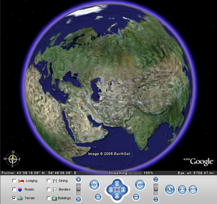
Google's project, within the framework of which satellite photographs of the entire earth's surface were placed on the Internet. Photos of some regions have an unprecedented high resolution.
Unlike other similar services that display satellite images in a regular browser (for example, Google Maps), in this service a special Google Earth client program downloaded to the user's computer is used. This approach, although it requires downloading and installing the program, but in the future provides additional features, difficult to implement using the web interface. This program was originally released by Keyhole and then bought by Google, which made the program available to the public. There are also paid versions of Google Earth Plus and Google Earth Pro, featuring support for GPS navigation, presentation tools and increased print resolution.
Opportunities:
- Google Earth automatically downloads images and other data necessary for the user from the Internet, saves them in the computer's memory and on the hard drive for further use. The downloaded data is stored on the disk, and at subsequent launches of the program, only new data is downloaded, which allows you to significantly save traffic.
- To visualize the image, a three-dimensional model of the entire globe is used (taking into account the height above sea level), which is displayed on the screen using the DirectX or OpenGL interfaces. It is in the three-dimensional landscapes of the Earth's surface that the main difference between the Google Earth program and its predecessor, Google Maps, lies. The user can easily move to any point on the planet by controlling the position of the "virtual camera".
- Virtually the entire surface of the land is covered with images obtained from DigitalGlobe with a resolution of 15 m per pixel. There are separate areas of the surface (as a rule, covering the capitals and some large cities of most countries of the world), which have a more detailed resolution. For example, Moscow was filmed with a resolution of 0.6 m/pc, and many US cities - with a resolution of 0.15 m/pc. Landscape data has a resolution of about 100 m.
- There is also a huge amount of additional data that can be connected at the request of the user. For example, the names of settlements, reservoirs, airports, roads, railways, and other information. In addition, for many cities there are more detailed information- street names, shops, gas stations, hotels, etc. There is a geodata layer (synchronized via the Internet with the appropriate database), which displays (with spatial reference) links to articles from Wikipedia. In Russia, you can see the street names of all cities in the central regions.
- Users can create their own labels and overlay their images on top of satellite images (this can be maps, or more detailed images obtained from other sources). These tags can be shared with other users of the program through the Google Earth Community forum. Tags sent to this forum become visible to all users of Google Earth after about a month.
- The program has a "3D Buildings" layer with 3D models added by developers or users themselves through the 3D Warehouse service. In the cities of Russia, you can find models of some significant architectural monuments.
- There is also a simplified Java version of the program for cell phones.
- There is a distance measurement function.
- In version 4.2, Google Sky technology appeared, which allows you to view the starry sky.
- In version 5.0, the ability to view a three-dimensional map of the bottom of the seas and oceans was introduced.

GeoMedia technology is a new generation GIS architecture that allows you to work directly without import / export simultaneously with a lot of spatial data in various formats. This is achieved by using special data access components - Intergraph GeoMedia Data Server.
Allows you to visualize and analyze spatial information (search, filtering by condition, dynamic visualization by condition or from changes in information in the database, buffer zones, statistics, proximity analysis, topological analysis (such as “is object A inside object B”, etc.) and many others), preparing maps for printing. For end users (non-GIS designers and administrators), run template queries in a customized work session environment. Directly (without conversion and damage at this moment of data) connects to the following information sources (servers and files in the corresponding formats): ArcGIS, MapInfo, MGE, GeoMedia (storage on the Microsoft Access platform, Microsoft SQL Server, Oracle Server), universal databases Oracle data Server, IBM DB2 and Microsoft SQL Server, vector maps or graphics in MicroStation (Bentley Systems), AutoCAD (Autodesk) formats, etc., raster data (with and without georeferencing) such as aerospace images and scanned paper map materials in TIFF formats, JPEG, CIT, RLE, etc., WMS Web Servers, spreadsheets, ODBC tabular data sources, and even ASCII texts (as full-fledged storage, but formatted, of course). Not suitable for editing and/or creating data (digital maps).
NASA World Wind
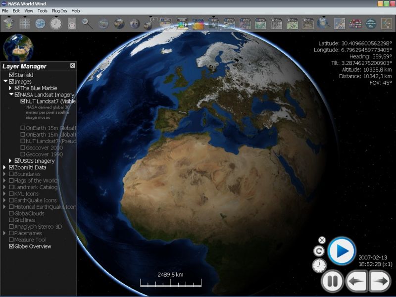
Fully 3D interactive virtual globe created by NASA. Uses NASA satellite imagery and USGS aerial photography to build 3D models of the planet. Initially, the program contains maps with low resolution. When approaching some area of interest on the map, high-resolution images are downloaded from NASA servers.
The program allows you to select the scale, direction and angle of view, visible layers, search by geographical names. It is possible to display the names of geographical objects and political boundaries.
The zoom function is implemented in World Wind as a change in the height from which the camera looks at the surface. From a great height, the image looks flat, but from a height of several tens of kilometers in the mountains, the effect of perspective is clearly visible, and the smooth scrolling of the image creates the impression of flying over the real terrain.
In addition to the image of the Earth, the program also shows the surface of the Moon. The images were obtained from the Clementine satellite, launched in 1994 and made about 1.8 million images during this time. NASA World Wind allows you to observe the Moon at almost any point on it by adjusting the image zoom. The image clearly shows the relief of the natural satellite, mountains, craters and crevices. Some of the images are so detailed that you can adjust the view of the moon's surface from twenty meters.
gvSIG

Free geographic information system with open source code
. The first working version appeared at the end of 2006 and was distributed via the Internet. It is a geographic information management toolkit with an intuitive clear interface, which works great with both raster and vector formats. gvSIG is being developed with a Spanish government grant.
The program supports all necessary GIS functions:
- Working with layers, thanks to which you can display only the necessary in this moment objects;
- Map zoom functions;
- Support for saving the necessary views of the map;
- Automatic calculations of distance between objects and areas of areas;
- Placement of active objects on the map;
- Creation of professional geographical maps with the necessary elements that can be subsequently printed.
ArcGIS
 A family of software products from the American company ESRI, one of the leaders in the global geoinformation systems market. ArcGIS is built on COM, .NET, Java, XML, SOAP technologies. Latest Version- ArcGIS 10.
ArcGIS allows you to visualize (represent in the form of a digital map) large amounts of geo-referenced statistical information. In the environment, maps of all scales are created and edited: from plans of land plots to a map of the world.
ArcGIS also has a wide range of tools for analyzing spatial information.
ArcGis is used in a wide variety of areas:
A geoinformation system designed for geomodelling, managing spatial vector and raster data, processing satellite images, creating printed cartographic products, and much more.
The package works with all modern DBMS, supports topology, 3D visualization, allows you to vectorize using various methods and has many other features inherent in expensive commercial products like ESRI ArcGIS or MapInfo. Thanks to these qualities, GRASS is widely used in commercial and scientific projects (for example, GRASS is actively used by NASA).
It should be noted that GRASS GIS is one of the oldest geographic information systems. Its development was initiated by the U. S. Army Construction Engineering Research laboratory in 1982. In 1995, the GRASS source code was released under the GPL.
The main feature of GRASS is its modular structure, which makes it possible to form a GIS optimized for the needs of the end user from individual functional units.
Main groups of modules:
- visualization;
- interaction with the DBMS (storage of spatial and attributive information);
- image processing (processing of satellite images, creation of composite images, geometric and chromatic correction);
- print management;
- work with raster maps (shade-models, scaling);
- work with vector maps (spatial analysis operations, attribute queries);
- and etc.
To work with map projections and coordinate systems, GRASS uses the proj library, which allows you to "understand" more than 30 thousand of their different types. Import and export is done through the GDAL library. Shapefile, MapInfo TAB, PostGIS, DXF, GeoTIFF, IMG and any other formats are supported.
Sources
- http://tinyurl.com/2ulhlrh
- http://en.wikipedia.org/wiki/ Today, GeoMedia users have access to components for all major industrial formats of digital cartographic data storage: ArcInfo, ArcView, ASCII, AutoCAD, FRAMME, GeoMedia, GML, MapInfo, MGE, MicroStation, Oracle Spatial, etc., including raster, tabular and multimedia data . Users can then design their own GeoMedia Data Server based on a custom format template. Intergraph GeoMedia Data Server components allow you to see and simultaneously analyze data from an arbitrary number of sources stored in different formats, coordinate systems with different accuracy on one map.This approach allows you to save investments in existing GIS solutions, while moving to new level integration of enterprise information resources.
The GeoMedia product family includes two basic product lines - desktop and server, plus additional application modules.
GeoMedia is the prototype of the first version of the international GIS standards developed by the Open GIS Consortium and, at the same time, is the first implementation of these standards.
Geographic information system
Geographic information system
Geoinformation systems(also GIS - geographic information system) - systems designed for the collection, storage, analysis and graphical visualization of spatial data and related information about the objects presented in the GIS. In other words, these are tools that allow users to search, analyze and edit digital maps, as well as additional information about objects, such as building height, address, number of residents.
GIS includes the capabilities of database management systems (DBMS), raster and vector graphics editors and analytical tools and is used in cartography, geology, meteorology, land management, ecology, municipal government, transport, economics, defense and many other areas.
By territorial coverage, there are global GIS (global GIS), subcontinental GIS, national GIS, often with the status of state, regional GIS (regional GIS), sub-regional GIS and local, or local GIS (local GIS).
GIS are different subject area information modeling, for example, urban GIS, or municipal GIS, MGIS (urban GIS), environmental GIS (environmental GIS), etc.; among them, a special name, as especially widespread, was given to land information systems. The problem orientation of a GIS is determined by the tasks it solves (scientific and applied), among them inventory of resources (including inventory), analysis, evaluation, monitoring, management and planning, decision support. Integrated GIS, IGIS (integrated GIS, IGIS) combine the functionality of GIS and systems digital processing images (remote sensing data) in a single integrated environment.
Multiscale, or scale-independent GIS (multiscale GIS) are based on multiple, or multiscale representations of spatial objects (multiple representation, multiscale representation), providing graphical or cartographic reproduction of data at any of the selected scale levels based on a single data set with the highest spatial resolution . Spatio-temporal GIS (spatio-temporal GIS) operate with spatio-temporal data. The implementation of geoinformation projects (GIS project), the creation of a GIS in the broad sense of the word, includes the following stages: pre-project studies (feasibility study), including the study of user requirements (user requirements) and functionality used software tools GIS, feasibility study, cost/benefit ratio assessment (costs/benefits); GIS system design (GIS design), including the pilot project stage (pilot-project), GIS development (GIS development); its testing on a small territorial fragment, or test area (test area), prototyping, or the creation of a prototype, or prototype (prototype); GIS implementation (GIS implementation); operation and use. The scientific, technical, technological and applied aspects of the design, creation and use of GIS are studied by geoinformatics.
History of GIS
Initial period (late 1950s - early 1970s)
Research of fundamental possibilities, frontier areas of knowledge and technologies, development of empirical experience, first major projects and theoretical works.
- The emergence of electronic computers (computers) in the 50s.
- The advent of digitizers, plotters, graphic displays and other peripheral devices in the 60s.
- Creation of software algorithms and procedures for graphic display of information on displays and using plotters.
- Creation of formal methods of spatial analysis.
- Creation of database management software.
The period of state initiatives (early 1970s - early 1980s)
State support for GIS stimulated the development of experimental work in the field of GIS based on the use of databases on street networks:
- Automated navigation systems.
- Systems for the removal of urban waste and garbage.
- Movement of vehicles in emergency situations, etc.
Period of commercial development (early 1980s - present)
A wide market for various software tools, the development of desktop GIS, the expansion of their scope through integration with non-spatial databases, the emergence of network applications, the emergence of a significant number of non-professional users, systems that support individual data sets on separate computers, open the way for systems that support corporate and distributed bases geodata.
User period (late 1980s - present)
Increased competition among commercial producers of geoinformation technology services gives advantages to GIS users, the availability and "openness" of software tools allows you to use and even modify programs, the emergence of user "clubs", teleconferences, geographically dispersed, but connected by a single theme of user groups, an increased need for geodata, the beginning of the formation of the global geoinformation infrastructure.
GIS structure
- Data (spatial data):
- positional (geographic): the location of the object on the earth's surface.
- non-positional (attributive): descriptive.
- Hardware (computers, networks, drives, scanner, digitizers, etc.).
- Software (software).
- Technologies (methods, procedures, etc.).
Questions that a GIS can answer
- What is in...? (location to be determined).
- Where is it? (spatial analysis).
- What has changed since...? (determine temporary changes in a certain area).
- What spatial structures exist?
- What if? (simulating what happens if you add a new road).
GIS in Russia
The most widely used in Russia from foreign systems are: the ArcGIS software product from ESRI, the GeoMedia product family from Intergraph Corporation and MapInfo Professional from Pitney Bowes MapInfo.
Of the domestic developments, the GIS Map 2008 program of the ZAO KB "Panorama" company has become widespread.
Others are also used software products domestic and foreign development: GIS INTEGRO, MGE of Intergraph Corporation (uses MicroStation as graphics core), IndorGIS, STAR-APIC, DoubleGIS, Mappl, GeoGraph GIS, etc.
Literature
- Zhurkin I. G., Shaitura S. V. Geoinformation systems. - Moscow: KUDITs-PRESS, 2009. - 272 p. ISBN 978-5-91136-065-8
- Brown L.A. History of geographical maps. Moscow: Tsentrpoligraf, 2006. - 479 p. ISBN 5-9524-2339-6 [History of GIS from antiquity to the twentieth century].
see also
General purpose GIS software products
Paid
Free
Specialized GIS software products
Non-profit organizations and associations
GIS Websites
GIS communities
- Official website of GIS Day (English)
- Open Geospatial Consortium (OGC) (English) is an international non-profit consortium of developers of open GIS technologies

1. What is a GIS?
GIS is a collection of computer hardware, geographic data and software for collecting, processing, storing, modeling, analyzing and displaying all types of spatially referenced information.
GIS is a medium that links geographic information (where what is) with descriptive information (what it is). Unlike regular paper maps (even scanned ones) that show what you see is what you get, GIS provides you with many layers of diverse general geographic and thematic information.

2. How is information stored in a GIS?
All initial information - where the points are located, what is the length of the roads or the area of the lake - is stored in separate layers in digital form on a computer. And all this geographic data is sorted into layers, with each layer representing a different feature type (theme). One of these topics can contain all roads in a certain area, another - lakes, and the third - all cities and other settlements in the same area.
http:// www.dataplus.ru/Arcrev/Number_43/1_Geograf.html
3. GIS can be considered in three forms:
GIS can be considered in three Views:
Database type: A GIS is a unique type of database about our world - a geographic database. This is " Information system for geography. A GIS is based on a structured database that describes the world in geographical terms, in terms of the spatial arrangement of its objects and phenomena.
Map type: GIS is a collection of smart maps and other graphic views, which show objects and their relationships on the earth's surface. Maps can be generated and used as a "window to the database" to support queries, analysis and editing of information. These actions are called geovisualization.
Model type: GIS is a set of tools for transforming information. They allow you to create new geographic datasets from existing ones by applying special analytical functions to them - geoprocessing tools. In other words, by combining data and applying some rules, you can create a model that helps you find answers to your questions.
http://www.dataplus.ru/Arcrev/Number_43/1_Geograf.html

4. What can be done with GIS?
Make spatial queries and analyze
search databases and perform spatial queries
identify areas suitable for the required activities; identify relationships between different parameters (eg soils, climate and crop yields); locate power outages
http://moslesproekt.roslesinforg.ru/activity/023gil-inform

5. Where are GIS applied?
Realtors use GIS to find, for example, all houses in a certain area
GIS serve to graphic construction maps and obtaining information as about separate objects
Engineering communications company
GIS helps, for example, in solving such problems as providing a variety of information at the request of planning authorities, resolving territorial conflicts, choosing optimal (from different points of view and according to different criteria) places for placing objects, etc.
http://gis-laris.narod.ru/primen_gis.htm

6. What is GPS?
GPS- satellite navigation system , which provides distance, time and location measurements.
http://ru.wikipedia.org/wiki/GPS

7. Who uses GPS?
GPS has a number of uses on land, at sea and in the air. Basically, they can be used anywhere where you can get a signal from the satellite, except inside buildings, in mines and caves, underground and under water.
http://www.1yachtua.com/Encycl/Elctrn/IspGPS.html

8. What is a GPS receiver (GPS navigator)?
GPS receiver- a radio receiver for determining the geographic coordinates of the current location of the receiver antenna, based on data on the time delays in the arrival of radio signals emitted by satellites of the NAVSTAR group. In Russia, with the development of the GLONASS system, serial production of GLONASS receivers began by a number of design bureaus and organizations.
http://ru.wikipedia.org/wiki/GPS-%D0%BF%D1%80%D0%B8%D1%91%D0%BC%D0%BD%D0%B8%D0%BA

9. How the cards are used in GPS receivers?
The presence of the card significantly improves the user characteristics of the receiver. Receivers with maps show the position of not only the receiver itself, but also objects around it.
All electronic GPS-maps can be divided into two main types - vector and raster.
http://wiki.risk.ru/index.php/GPS-%D0%BF%D1%80%D0%B8%D0%B5%D0%BC%D0%BD%D0%B8%D0%BA

Geocaching(geocaching from Greekγεο- - Earth and English cache- hiding place) - travel game with the use of satellite navigation systems, which consists in finding hiding places hidden by other players in the game.
http://en.wikipedia.org/wiki/%D0%93%D0%B5%D0%BE%D0%BA%D0%B5%D1%88%D0%B8%D0%BD%D0%B3

11. Who plays geocaching?
It can be played with family, company or alone
Geocaching is actively used as a corporate entertainment. Employees of the providing company hide caches, instruct participants, provide them with equipment and GPS-navigators.
http://ru.wikipedia.org/wiki/%C3%E5%EE%EA%FD%F8%E8%ED%E3

12. What is Google Earth?
Google's project, within the framework of which satellite photographs of the entire earth's surface were posted on the Internet. Photos of some regions have an unprecedented high resolution.
In many cases Russian google version Earth is called Google Earth, for example, in the main menu or on the official website.
http://ru.wikipedia.org/wiki/GoogleEarth

13. Features of Google Earth?
- View satellite images - easy navigation, seamless connection of satellite images and instant display with gradual drawing of details;
- Construction of perspective (relief) images with overlay of satellite images;
- Drawing your points, lines and polygons and exporting them to special file(in Google format) for sharing with other GE users;
- Superposition of own images (for example, logos, own maps, etc.) and their approximate alignment with the underlying surface;
- Distance measurement;
- Flying around the territory at a given height and speed.
http://gis-lab.info/qa/google-earth.html


2 GIS Saratov
http://saratov.2gis.ru/

Practical work "2 GIS Saratov"
Exercise 1: Using the Catalog tool (in the upper left corner of the program), view the catalog of organizations in the city of Saratov.
Task 2: Use the "Search" system. Enter the address (optional), district. The program will automatically indicate the required address.
Task 3: Use the block to build a public transport or car route between any points on the map "How can I get to?" tab Search.

Geographic information system - a system for collecting, storing, analyzing and graphical visualization of spatial (geographical) data and related information about the necessary objects. It is also used in a narrower sense - as a tool (software product) that allows users to search, analyze and edit both a digital map of the area and additional information about objects.
"Geographic Information System"- this is a set of hardware and software tools and algorithmic procedures designed to collect, input, store, mathematical and cartographic modeling and figurative representation of geospatial information.
Geospatial data" means information that identifies the geographic location and properties of natural or artificial objects, as well as their boundaries on earth. This information can be obtained through (among other means), remote sensing, mapping and various types of surveys.
Geographic data contains four integrated components: location,
Properties and characteristics, spatial relationships, time.
GIS: geography, cartography, remote sensing, topography and photogrammetry, informatics, mathematics and statistics.
2. Spheres of use of gis.
GIS includes the capabilities of database management systems (DBMS), raster and vector graphics editors and analytical tools and is used in cartography, geology, meteorology, land management, ecology, municipal government, transport, economics, defense and many other areas.
3. Classification of gis.
By functionality: - full-featured general-purpose GIS;
Specialized GIS, focused on solving a specific problem in any subject area;
Information and reference systems for home and information and reference use. The functionality of GIS is also determined by the architectural principle of their construction:
Closed systems do not have expandability, they are able to perform only the set of functions that is uniquely defined at the time of purchase; - open systems are easy to adapt, expandable, as they can be completed by the user using a special apparatus (embedded programming languages).
According to the spatial (territorial) coverage, GIS are divided into global (planetary), national, regional, local (including municipal).
By problem-thematic orientation - general geographic, environmental and nature management, sectoral (water resources, forest management, geological, tourism, etc.).
According to the method of organizing geographic data - vector, raster, vector-raster GIS.
4. Structure of gis.
Non-positional (attributive): descriptive.
Data (spatial data):
Positional (geographic): the location of an object on the earth's surface.
Hardware (PC, networks, drives, scanners, plotters, etc.).
Software (software).
Technologies (methods, procedures, etc.).